|
This is the cloudiest and windiest place on the planet,"
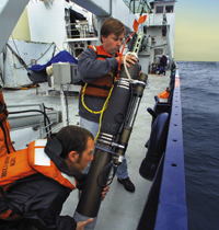
said oceanographer Jim Bishop, after the robotic floats were
deployed from the research vessel Revelle as part of
SOFeX, the Southern Ocean Iron Experiment. "The float
in the center of the fertilized patch just keeps sending--its
antenna is spectacular. I call it 'the little float that could.'"
SOFeX, a multi-ship project led by Moss Landing Marine Laboratory
and the Monterey Bay Aquarium Research Institute, fertilized
plankton by adding scarce iron to otherwise nutrient-rich
waters. Because phytoplankton grow using carbon dioxide, ocean
fertilization has been touted as a way to control global warming.
|
|
 |
 |
| |
|
| |
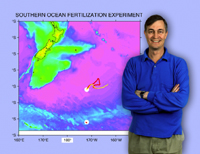
Jim Bishop and his colleagues devised
instruments that SOLOs could use to measure both organic
carbon particles, like plankton, and inorganic, like calcite,
the most common carbon mineral in seawater. The map shows
SOLO following the iron-fertilized water. |
| |
|
Berkeley Lab researchers had earlier led a collaboration
to equip SOLO floats (Sounding Oceanic Lagrangian Observers),
designed at the Scripps Institution of Oceanography to measure
temperature and salinity at various depths, with particulate
organic carbon detectors plus global positioning and fast
communications systems. Remotely programmable Carbon Explorers
were the result.
During SOFeX the Revelle, with Berkeley Lab researchers
Todd Wood, Christopher Guay, and Phoebe Lam aboard, pumped
iron into two areas along 170 degrees west longitude. In the
"howling 50s" of seagoing lore, the ocean is poor
in the silicates some phytoplankton need to form shells, so
plankton was expected to bloom sluggishly there even after
fertilization. A more vigorous bloom was expected after fertilization
of the silicate-rich waters farther south in the 60s.
The northern fertilized region promptly divided into two
patches. Revelle launched three floats, the last programmed
to stay in the center of the main patch. While the research
vessel Melville and the U.S. Coast Guard icebreaker
Polar Star later performed follow-up studies, the Carbon
Explorers operated continuously and independently, diving
and resurfacing each day to report. When high winds interfered
with communication, data were saved and played back later.
"The floats were diving to depths as great as 1,000 meters
every day, but we programmed them to 'sleep' at 100 meters
so that they would follow surface waters best," Bishop
explains. There was a risk, however: "By staying shallow
in the middle of the plankton bloom, the instruments--which
measure particulate matter by how much light is transmitted
through the water--might become fouled."
Revelle headed south to fertilize the second patch
of ocean; there the final Carbon Explorer experienced similar
storms but much-reduced satellite coverage. Heard from only
once in the next three weeks, it finally reestablished contact
and played back most of its data.
Meanwhile Bishop, using his laptop back in Berkeley, was in
daily contact with the northern floats. "Our guess at
how to program the floats to stay with the patch, plus a simple
change in configuration to reduce biofouling, paid off in
a big way," says Bishop. The two floats stayed with the
patch, one near its center, the other just outside, serving
as a control.
|
|
 |
 |
| |
|
| |
|
| |
|
| |
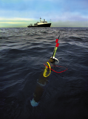
Deep-diving SOLO floats like the one
shown here have been specially equipped to report on biological
activity in the sea.
A flotilla of SOLOs faithfully tracked a plankton bloom
through the stormy Southern Ocean as part of SOFeX, an
experiment to test the "iron hypothesis," the
proposal that phytoplankton blooms can lower global temperature
by removing carbon from
the atmosphere. |
| |
|
Just before Revelle returned to the northern patch in early
February, guided by the floats' accurate GPS positions, the
skies cleared and the ship received the first color image
of the area in over three weeks from NASA's SeaWIFs satellite.
Despite expectations that growth would be poor, Bishop reported,
"we can confidently say that particulate organic carbon
in the patch has grown to be four or five times that outside
the patch."
Revelle returned to port, but the northern Carbon Explorers
kept reporting, despite days when winds exceeded 50 miles
per hour and swells averaged 40 feet from trough to peak.
By June all three northern floats had traveled over a thousand
kilometers.
The lone Carbon Explorer in the south reported periodically
until late in the Antarctic autumn, when it was overtaken
by advancing pack ice. Its data allowed glimpses of life at
1.5 degrees Celsius below zero. "That's about as cold
as the ocean can get, and now it's almost perpetually dark,"
Bishop remarked.
In mid-June, Bishop reported that after a month of repeated
"bonkings" under the ice, the indomitable Explorer
reappeared, probably surfacing through leads in the ice. It
reported its position and transmitted data stored from over
two weeks of diving in the freezing dark.
Long after all SOFeX ships had returned to port, the Carbon
Explorers were still on the job, more than half a year since
their launch. In July, 2002, Bishop reported "We still
have direct control of the Explorers, even though they are
half a world away and operating in conditions akin to those
experienced by Shackleton and his men." No other approach
to investigating the ocean's carbon budget could have matched
the performance of these intrepid robots.
The Carbon Explorers were developed with support from the
National Oceanographic Partnership Program. Their deployment
during SOFeX was supported by the Department of Energy's Office
of Science, Ocean Carbon Sequestration Program.
-- Paul Preuss
|


